Northwest Michigan fruit update – April 27, 2021
Sweet cherry bloom is beginning in the region and PGRs like ReTain will be less effective in cool weather.

Weather report
Last week’s freezing temperatures have growers and Michigan State University Extension educators assessing the buds of the many fruit crops for freeze damage. Overnight temperatures dipped below freezing on the evening of April 20 into April 21. There were varying degrees of cold temperatures across the region that evening. The coldest temperature on the evening of April 20 reached down to 24.8 degrees Fahrenheit for one hour. The duration of the below freezing temperatures on that evening were noticeable as most MSU Enviroweather stations recorded cold from 10 p.m. until 10 a.m. the following morning. Temperatures on April 22 were warmer than the previous night, but many stations still recorded a full evening into early morning of below freezing temperatures.
The two nighttime temperatures were above the damaging levels of our ongoing programmable freezer trials. However, our trials are conducted in our freezer that does not take ambient conditions, wind, or other variables into consideration. Again, we are still cutting buds to determine the impacts of these cold temperatures on the region’s crop.
According to MSU state climatologist Jeff Andresen, 80% of state is in some stage of moderate to high levels of drought. However, the warm moving from the southwest into northeast will bring a warm air mass coupled with high levels of humidity. There are chances of isolated thunderstorms today and into this evening, especially in the lower half the state where it is predicted to be much warmer. There are also chances of hail where warm air and cold air meet. The temperature differentials from south to north throughout the state are particularly notable. Southern Michigan is forecasting temperatures in the 70s and even low 80s while here in northwest Michigan, Traverse City is predicting a high of 62 F and Northport is only predicting to be a high of 50 F. The warm front will only reach as far as M-72, but the cold air mass from Lake Michigan may keep the warm weather further south.
Late Wednesday into Thursday, a weather front will stall over the state. Temperatures will remain warm to south and cold to the north, but overall temperatures for Wednesday and Thursday (April 28 and 29) will be cooler than Tuesday due to high levels of cloud cover. Cool, fair, and dry air moves back in on Friday and into the weekend. There will be the potential for scattered frost on Friday or Saturday morning, but mostly in low lying areas—most overnight temperatures will be in the mid-30s F.
Higher precipitation and warmer than normal temperatures are in the medium range forecast for the first week of May.
View Andresen’s weekly weather report.
Crop report
As mentioned above, we are still investigating the impacts of the cold nights last week. Interim reports suggest that tarts have more damage than sweet cherries. We did observe a slightly brownish tings to the reproductive parts of sweet cherries rather than the distinctive dark brown color we associate with flower death.
Apples are still looking green, but we can find some death in king bloom at the Northwest Michigan Horticulture Research Center. However, at this time, our bud assessments have been mostly localized, and we will not know the impact of the freezing temperatures for some time. Additionally, we are still quite early in the growing season, and we have some time to go before harvest.
One of the main issues that is on growers’ mind is using ReTain for sweet cherries. The effectiveness of this plant growth regulator (PGR), as with all PGRs, is dependent on temperature. Although the forecasts seem to be all over the board in the state, the general trend of daytime highs in northwest Michigan are to be cool today (highs of mid-50s) and through the weekend. ReTain lasts for three, at most four, days in cherry, so the chance of this PGR working at these extremely cool weather conditions over the next few days is quite low.
Additionally, ReTain works by extending the viability of the ovule. At these cool temperatures, the ovule will remain quite static and ReTain will not extend the viability more in cool weather. The bigger concern would be if we suddenly got warm and the ovule viability decreased faster at high temperatures, ReTain would work to extend ovule viability to allow for pollen tube growth to make it to the ovule for successful pollination.
Regina has been a variety where we have seen excellent results with ReTain use. This variety is also later blooming, and one strategy to use ReTain in 2021 is wait until temperatures warm next week before applying ReTain for improve efficacy; in many locations, Regina is still quite tight in bud development. Data have also shown ReTain to work better when applied earlier, popcorn to first bloom, which many Regina blocks will be in early next week.
Pest report
Temperatures continue to be cold, which has not favored apple scab development during recent rainy/snowy weather. Daytime temperatures on Friday, April 23, and Saturday were in the upper 50s into the 60s, which allowed for some leaf growth on apples which have been at tight cluster since April 9. Most growers have recovered apples ahead of upcoming rains forecasted to begin today through Thursday. Currently, the best chance for rain looks like this evening into Wednesday morning. By Wednesday afternoon, the chance for rain lessens.
If intermittent rain events occur and do not allow sufficient drying time between the events, there is the possibility for a disease infection event. The rain and warmer temperatures in the forecast will help to push development and growers are planning the next fungicide cover. Links to the apple scab model on RIMpro are below. These models are currently forecasting that spores will be discharged during rains today and tomorrow and that an infection is possible if conditions remain wet and/or humid.
Sweet cherries have started blooming in the region, and current cooler temperatures are not as favorable for American brown rot development. We remind growers planning bloom protection for this disease that for resistance management purposes, Rovral is the suggested fungicide to use for blossom blight prevention.
Growers have been concerned about this spring’s cool and potentially wet conditions, which are ideal for European brown rot development. Furthermore, there are varying levels of bud damage in tart cherry blocks in the region and growers are thinking about how to strategize management programs. The European brown rot pathogen can infect flowers in bloom even if the pistils are dead. Infection that occurs through the flowers can spread into the spurs and branches, resulting in limb dieback and lingering inoculum for future seasons. Fortunately, most orchards have not had significant European brown rot infections in recent years and inoculum levels should be low.
Traditionally, the suggested management approach for this disease is two applications, the first during popcorn followed by a second application about seven days later around full bloom. This season, in Montmorency orchards with low inoculum, growers may only need one application to manage this disease weather permitting. In orchards with high risk of infection (for example Balaton, slow drying Montmorency orchards), the traditional management strategy should be used.
Continue to monitor bud development and the weather to optimally time at least one application around bloom time to prevent infections; two applications may be needed if conditions are optimal during popcorn and bloom. If conditions are not cool and wet during popcorn, wait until bloom to make the application.
Unlike the American brown rot pathogen, European brown rot is still sensitive to the fungicide, Indar. Indar at the 6 fluid ounce rate continues to be the choice material for blossom protection from European brown rot. There are other fungicides that would also be effective against European brown rot and growers can review those in the Michigan Fruit Management Guide. Also, consider processor restrictions as you choose a course of action.
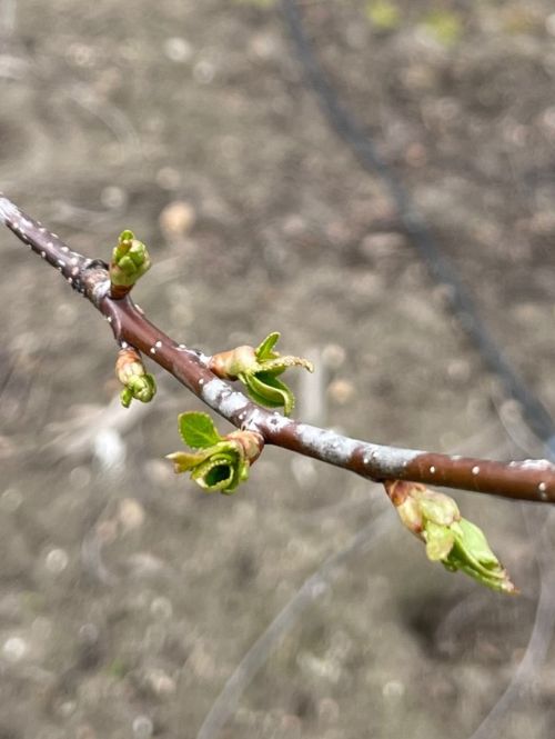
Bract leaves are emerging in warmer areas of the region on vegetative buds (see photo at beginning of article). As noted in previous reports, we have observed cherry leaf spot infecting bract leaves during optimal conditions. Optimal temperatures for rapid leaf spot development are in the 60s. However, this disease will grow at lower temperatures in the 40s and 50s. Although temperatures are still cool, daytime highs could reach into 50s and 60s, and conditions could be wet for long enough for an infection to occur in areas where susceptible tissues are present.
In most areas, tart cherry buds have little to no bract leaves present and there is little concern for an infection during rains predicted for the early part of this week. Determining when to initiate cherry leaf spot management programs has been a challenge in recent years, and we are hoping that new research at the station will help to refine that timing.
In apples, we are finding small leaf roller larvae and aphids. European red mite eggs look healthy, but we have not observed hatch at this time. No oriental fruit moth or black stem borer were found in our trapline this week. Spotted tentiform leaf minor activity is ongoing with low trap catches this week.
We have not observed plum curculio and have not received reports of the beetles or damage from them in orchards. Conditions were cooler than predicted over the past week and ongoing cool weather will likely continue to delay their emergence.
No American plum borer were found this week.


 Print
Print Email
Email
