Northwest Michigan fruit update – May 13, 2025
 Print
Print Email
EmailSweet cherries are in full bloom, and tart cherries are close behind at 50% bloom. Apples are at pink, and growers are busy with bloom activities.
Weather report
We had continued cool weather at the end of last week and through the weekend. Daytime highs were in the mid-50s on Friday and Saturday, May 9-10, and those cool temperatures were accompanied by windy conditions that made the air temperatures feel even colder. Temperatures warmed on Mother’s Day, May 11, and we were happy to see daytime highs in the low to mid-70s. On Monday, May 12, we almost hit 80 degrees Fahrenheit at the Northwest Michigan Horticulture Research Center, and working outside seemed quite hot for this time of year. The weather forecast has been predicting more warm and dry conditions, but today, May 14, the forecasts changed, and the weather will cool as we head into the weekend. Daytime highs for this weekend are predicted to be in the mid-50s.
In addition to the cool down, the forecast for this week predicts small, pop-up type showers. The actual percentages for rain are small and annoying if growers are considering disease management actions to protect against fungal pathogens. At this time, our growing degree day (GDD) accumulations remain similar to our 35-year averages: 351.3 GDD base 42 and 159.2 GDD base 50. The 2025 accumulations are as follows: 355.4 GDD base 42 and 159.2 GDD base 50—our 2025 GDD base 50 is exactly the same as our 35-year average!
According to Jeff Andresen, Michigan State University (MSU) climatologist, there has been a second unique weather phenomenon again called a cut-off low that has been reported in Michigan over the weekend. A cut-off low is a low-pressure system that becomes detached from the main jet stream and can drift for days, causing persistent, often unsettled weather. These systems can bring rain, thunderstorms, and are known for being difficult to predict precisely.
Again, as a result of this weather pattern, the northwest region of the state was warmer and drier than the central and southern parts of Michigan. Our region remains quite dry, and the last significant rainfall was recorded May 1 where the MSU Enviroweather station recorded 0.63 inches of rain. However, the weather has now changed again! As of this morning, we have had rainfall in different locations throughout northwest Michigan. Growers need to watch the radar and rain gauge carefully to help make disease management decisions with the sporadic rainfall events. Rainfall events may not be adequately captured by Enviroweather stations if the rains are spotty and isolated.
The medium-range forecast is now cooler and wetter than normal through the last week of May—this forecast is completely opposite of the prior week’s predictions. Good news is that Andresen predicts we are outside of frost/freeze potential for the season.
Crop report
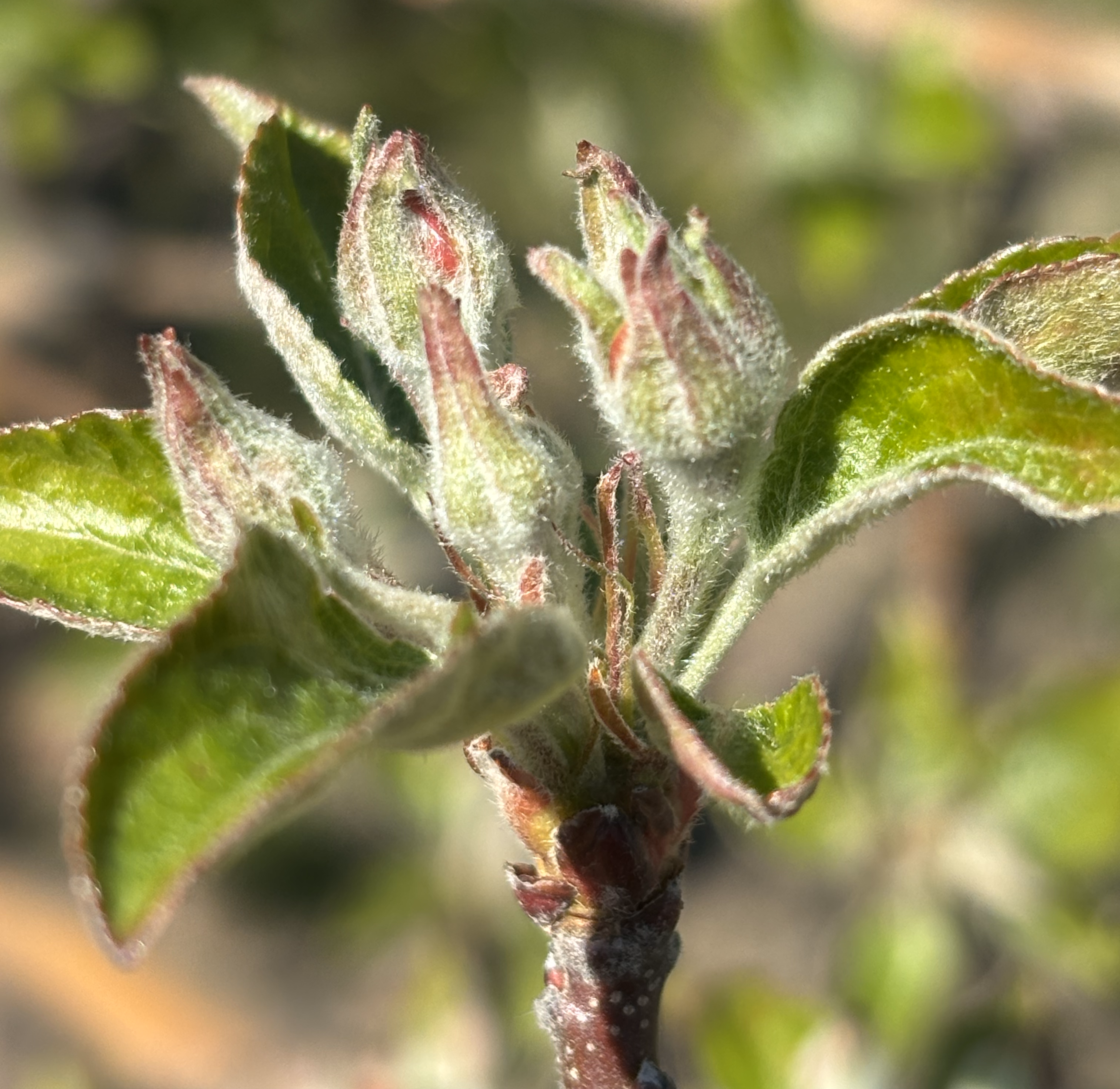
The crop development continues to move along, especially with the recent warm weather. Montmorency tart cherry is at 50% bloom, and Balaton is at 75% bloom. All varieties of sweet cherry at the Northwest Michigan Horticulture Research Center are at 100% bloom. Gala are at early pink, and Honeycrisp are at pink. This slight change is switched as Gala came out of dormancy moving faster than Honeycrisp, but both are close to the same stage this week.
For reference, the growth stages collected at the Trevor Nichols Research Center on April 28 are as follows:
- Apples – bloom (Enterprise, Golden Delicious), petal fall (Red Delicious, Empire, JonaMac, Red Chief, Crimson Gold)
- Blueberries – bloom
- Cherries – petal fall
- Peaches - petal fall
- Pears – petal fall (May 9, 2025)
- Plums – petal fall (April 25, 2025)
Disease report
In general, growers are going to be challenged in making disease control decisions this week because the weather forecasts continue to change. As mentioned above, the weather forecast started out as warm and dry with no rainfall in the forecast. Now, all weather apps are predicting days with rain with very low chances for actual precipitation. For instance, my phone is predicting rain today, and every day through Sunday with percentages ranging from 35% to 55%. Andresen believes that the highest chance of rain is Thursday, May 15. With such variable rainfall predictions, growers will need to decide if and when they should cover for fungal diseases.
The following are total accumulations for our local Enviroweather stations: East Leland 0.02 inches, Eastport 0.03 inches, Benzonia 0 inches, Kewadin 0 inches, Northport 0 inches, Old Mission 0.07 inches, Northwest Michigan Horticulture Research Center 0 inches, Williamsburg 0.07 inches and Bear Lake/Onekama 0 inches. From these totals, rainfall looks sparce in the region, but there have been reports of isolated downpours, big puddles and other signs of higher rainfall in isolated areas.
With these recent, somewhat unusual weather patterns, growers should err on the conservative side and protect new green tissue against fungal diseases, especially so early in the season. Keep an eye on the relative humidities as they are predicted to be high over the next three days. Relative humidity over 80% will continue a wetting event and increase infection potential for many fungal diseases.
Apple scab. There is a significant amount of green tissue out on most varieties of apples across the region, and growers should be covering this tissue before the next rain is in the forecast, which as mentioned above is complicated with the weather forecasts. Growers should be getting a jump on apple scab control early in the season to keep scab at bay through primary scab to avoid having to fight this disease on fruit during the secondary phase of this disease later in the season. Be sure to apply fungicides to protect this new tissue from the apple scab pathogen.
Optimal conditions for apple scab are wet and warm conditions. With warmer average daily temperatures, fungi require less time to grow and initiate infection compared to cool temperatures. If growers have already applied fungicides for scab, and with the small amounts of rain in the forecast, consider if another fungicide application is needed. For example, if the previous spray was seven to 14 days ago, another protective spray may be needed to cover new and existing tissue. However, if a fungicide was applied more recently, fungicide residue should still be present. A general rule of thumb that is often used is that 1 inch of rain removes about 50% of the protectant fungicide residue, and over 2 inches or rain will remove most of the spray residue.
The MSU fruit team will be using the RIMpro model to help growers manage apple scab throughout the season. “How to interpret a RIMpro apple scab forecast when making management decisions for your operation” is a great article on how to use RIMPro to best predict scab in regional orchards. There are significantly more spores mature this week than at this same time last week. The RIMpro models are predicting that about 40% spores are mature, which means we still have a long way to go for scab season. The noticeable piece of this week’s RIMpro outputs are the high to extreme infection risks on May 13-16. Again, this model is taking forecast data from the MSU Enviroweather stations (Williamsburg, Benzonia and East Leland) to predict the risk of infection by the apple scab pathogen. Refer to this model regularly as the rainfall predictions are changing often. RIMpro’s risk for predicting scab infections has increased significantly since checking the models on Monday since rain has moved into the region.
Here are the following links for RIMpro outputs from May 13:
Powdery mildew. Growers need to be actively controlling mildew if they had problems with this disease in 2024. Remember that apple powdery mildew fungal spores (conidia) cannot germinate in free water, and they prefer warm, humid conditions with relative humidity greater than 60%. We will have good conditions for mildew with the warmer weather and potentially isolated and short rainfall events. Sulfur is a good material early, but do not spray sulfur during bloom or during apple thinning. Tight cluster through petal fall is a critical time for powdery mildew control, and single site fungicides should be used: SHDIs (Miravis, Tesaris, Merivon), QoIs (Flint Extra), and DMIs (Rhyme).
American brown rot. American brown rot is favored by warm and wet conditions. In mist chamber work, we reached 80% American brown rot infection in 4 hours at 68 F compared to 80% infection in 24 hours at 46.4 F. The warmer and wetter, the faster the fungus moves.
In talking with George Sundin, MSU Extension tree fruit specialist, today, he mentioned this disease needs significant water to initiate an infection period. Unlike powdery mildew, American brown rot needs a good amount of rain for an infection period. That type of rainfall is not currently in the forecast, so his recommendation is as follows: Because weather conditions have been so dry, one brown rot spray is likely sufficient unless an orchard had high disease pressure from last season. If growers have not applied a brown rot spray yet this year, an application may be needed before petal fall. Use Rovral at 2 pints per acre; this is the material of choice since Rovral cannot be applied after petal fall, and we have limited materials to control American brown rot closer to harvest. Rovral cannot be applied more than twice per season, nor past petal fall.
Cherry leaf spot. Bract leaves are starting to open in many orchards across the region. From recent work, we found that bract leaves first emerge at popcorn or around 220 GDD base 42. Bract leaves have fully emerged at 230 GDD base 42, which also coincides with the start of bloom in Montmorency. At 250 GDD base 42, bract leaves have fully emerged, and this is the time when growers should use as their biofix date for the cherry leaf spot model. We are at 351 GDD base 42 at the Northwest Michigan Horticulture Research Center today, so be ready to apply materials to protect against cherry leaf spot if we do have rain. As soon as those leaves open, the stomata, even on those tiny bract leaves, are susceptible to leaf spot.
Again, watch the weather to make decisions to cover for cherry leaf spot. If the previous spray was seven to 14 days ago, another protective spray may be needed to cover new and existing tissue. However, if a fungicide was applied more recently, fungicide residue should still be present.
Pest report
With a few warm days, there is more happening in the insect world as they become more active in the orchard. San Jose scale, lesser and American plum borers were not caught at the Trevor Nichols Research Center this week, but they did catch codling moth. In fact, they had 8.7 moths per trap. They are still catching plum curculio. Here at the Northwest Michigan Horticulture Research Center, we caught a few spotted tentiform leafminers and two black stem borers.
American plum borer. We caught American plum borer for this the first time this week. We caught an average of four months per trap.
Green fruit worm. We caught an average of 8.3 green fruit worm this week, and we have caught them for the last four weeks.
Black stem borer. We caught black stem borer at the Northwest Michigan Horticulture Research Center again this week. We caught one beetle last week and two this week. We are at 355.4 GDD base 50 compared with last week at this time where we had accumulated 159.2 GDD base 50. The beetles should be near peak flight, but our trap catches at commercial sites with huge past populations did not catch as many beetles as we anticipated. We expected higher trap counts with the warm temperatures, but we will keep you updated on black stem borer activity this week.
Two applications of pyrethroids as trunk sprays are recommended for orchards with past black stem borer pressure. The MSU Tree Fruit Entomology lab has been conducting black stem borer efficacy trials. From the 2024 data, Assail with the adjuvant Widsepread had better control than Assail alone; the Widespread adjuvant did not improve efficacy when combined with Warrior II compared to Warrior alone. Adjuvants may improve insecticide efficacy.
San Jose scale. We did not catch San Jose scale in traps this year. As mentioned above, they are still not catching San Jose scale at the Trevor Nichols Research Center this week. If growers missed oil at the delayed dormant timing, recent data show that Esteem 0.86EC at 16 ounces at pink provided excellent control of San Jose scale in a particularly high-pressure block. Centaur 70WDG at a rate of 34.5 ounces at the pink timing provided good control of this pest. In short, if growers missed their oil applications, they should target the pink stage with Esteem or Centaur. We are at pink in Honeycrisp and Gala at the Northwest Michigan Horticulture Research Center.
Plum curculio. We are trapping for this pest at grower sites, and this week we caught over 80 plum curculio in an organic cherry block. From past research, we showed that plum curculio overwinter within an organic orchard at significantly higher rate than in conventional orchards. In conventional blocks, plum curculio were found to overwinter in adjacent, wooden areas surrounding the orchard and migrate into the block in the spring.
Again, for this pest, we caught more beetles than anticipated with the dry conditions. Plum curculio becomes active with overnight temperatures over 65 F, and they do prefer moisture or humidity to increase activity. We have had dry conditions with isolated warm days and nights, so we predict this pest will be more active when we hit these ideal conditions.
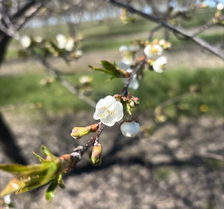
Additionally, this pest is a threat to fruit as it comes out of the shuck. The females will oviposit eggs into the fruit as soon as the fruitlet is visible. We are still only at bloom in sweet and tart cherry, so plum curculio is not a concern in these crops at this time. Growers with apricots should be using insecticide to protect fruit against ovipositing female plum curculio. With the recent overnight higher relative humidity and isolated rainfall, plum curculio activity will likely increase.
This work is supported by the Crop Protection and Pest Management Program [grant no 2024-70006-43569] from the USDA National Institute of Food and Agriculture. Any opinions, findings, conclusions, or recommendations expressed in this publication are those of the author(s) and do not necessarily reflect the view of the U.S. Department of Agriculture.